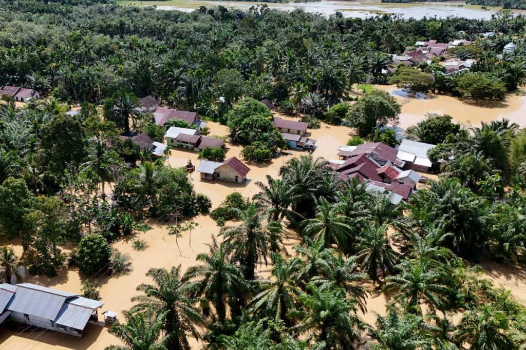
Why Do Floods Keep Happening in Aceh?
By Eka Yudha Saputra for Tempo.co, November 19, 2026
Tempo magazine reports the floods that struck Indonesia’s northern Aceh province again in November 2026 show post-disaster recovery is not addressing the root causes of the problem.
As heavy rains fall again, rivers overflow, residential areas are inundated, and people have to evacuate once more. A report from the National Disaster Management Agency (BNPB) on Tuesday, November 17, 2026, recorded flooding across Aceh Singkil, South Aceh, and Subulussalam City.
In Aceh Singkil, from Friday, November 13, 2026, rain caused the Lae Cinendang and Lae Soraya rivers to overflow. Floodwater inundated the homes of 3,517 families in five districts. A concrete bridge abutment in Sebatang Village collapsed, and five electricity poles fell. In Selok Aceh Village, a box culvert, a drainage culvert, and a bridge were damaged, while a road in Cingkam Village was cut.
This latest flooding occurs just two weeks after BNPB sent a circular to local government authorities on Friday, October 30, 2026, urging greater preparedness for major rain events. BNPB chief Lieutenant General Kristomei Sianturi said the central government has reminded local authorities to take preventative measures early.
“On October 30, 2026, we issued a circular to local governments urging them to anticipate the threat of flooding disasters,” he told reporters while visiting Subulussalam City on Tuesday, November 17, 2026.
Kristomei said local governments should prepare disaster-risk assessments to determine priority areas for mitigation and preparedness measures. The central government, he said, would provide assistance if local authorities were unable to address the threat.
“What are the mitigation priorities, and how prepared are you? If the local government cannot handle things, then the central government will help,” he said.
The high risk of flooding in several parts of Aceh is reflected in the 2025 Indonesian Disaster Risk Index. South Aceh scored 246.38 and Aceh Singkil 235.34, both classified as high risk. Subulussalam scored 165.78, a moderate-risk rating. The data show that the threat of disaster in these areas is not a new problem that has appeared out of nowhere.
Upstream
Flood management cannot focus only on areas that are inundated. Risks downstream are closely linked to environmental conditions and the management of upstream areas.
Acting Head of the BNPB Center for Data, Information, and Disaster Communication, Berton S.P. Panjaitan, explained that flooding in Aceh Singkil and South Aceh is also affected by land cover, rainfall, and water flows in the upper reaches of the Alas-Singkil watershed. Those upstream areas may fall administratively within other districts.
Coordination
The Aceh WebGIS dashboard, a digital mapping system that integrates BNPB and InaRISK data with geospatial information, also identifies the Alas-Singkil watershed as an area requiring cross-regional risk management. This means efforts to reduce flooding downstream cannot be given only to the district government where the flooding occurs. Managing upstream and downstream areas requires coordination among local governments.
Berton said BNPB’s assessment found three main obstacles to disaster mitigation in Aceh: slow on-the-ground response, inaccurate prioritization of disaster-prone areas, and weak coordination in relaying warnings from the meteorology agency BMKG down to the village level.
“BNPB’s assessment found three obstacles to mitigation: slow on-the-ground response, inaccurate prioritization of disaster-prone areas, and weak coordination in passing BMKG warnings down to villages,” he told Tempo on Wednesday, November 18, 2026.
Weak mitigation is also reflected in post-disaster rehabilitation and reconstruction that hasn’t been resilient enough to withstand subsequent disasters. The Task Force for Accelerating Post-Disaster Rehabilitation and Reconstruction in Sumatra reported that physical recovery has reached 96–98 percent as of October 26, 2026. However, flooding in November 2026 has again damaged infrastructure in Aceh Singkil.
Stronger infrastructure resilience
Berton said rehabilitation and reconstruction in Aceh, North Sumatra, and West Sumatra were being carried out alongside mitigation efforts to reduce the risk of further disasters. The government, he said, cannot simply repair damaged infrastructure while the threat of floods and landslides remains.
Physical recovery must be accompanied by stronger infrastructure resilience to weather hazards. “The return of flooding in Aceh Singkil in November 2026 shows that infrastructure recovery must be followed by stronger resilience to weather hazards,” he said.
Ecological vulnerabilities
Beyond infrastructure, post-disaster recovery has failed to address ecological vulnerabilities that contribute to recurring floods. Eko Teguh Paripurno, a lecturer in disaster management at the “Veterans” National Development University in Yogyakarta, said the government had focused too much on physical construction without restoring the ecosystems of water-catchment areas.
Environmental damage, however, is reducing nature’s capacity to support life. “In disaster management, there is a saying: disasters are certain to recur because vulnerabilities are forgotten and left unrepaired,” he told Tempo on Wednesday, November 18, 2026. “A threat comes, a disaster occurs, the vulnerabilities are not addressed, and then the threat comes again,” he added.
According to Eko, housing and infrastructure recovery in Aceh has begun, but ecological restoration is lagging behind. As a result, even relatively light rainfall can trigger flooding.
Filled with debris
Rivers are still filled with debris, the land has become fragile following the effects of the previous cyclone, and surface runoff is greater than water absorption. Drainage systems that have not been restored also increase the risk of overflow, while areas that have previously been inundated have low absorption capacity.
For that reason, Eko said, dredging rivers and raising embankments alone would not be enough to address recurring floods. The government needs to restore ecosystems while also building water-infiltration systems in residential areas. “Raising embankments is the most conventional approach. But the best approach is to restore ecosystems in parallel while building infiltration wells,” he said.
Forest coverage
Anggi Putra Prayoga, a forest campaigner with Greenpeace Indonesia, also criticized environmental damage. He said damage to watersheds in Aceh had reached a critical level. Based on Greenpeace’s watershed analysis, forest cover on Sumatra is now below 20–25 percent, far below the safe threshold for environmental carrying capacity.
The loss of the soil’s ability to absorb water and poor forest-management policies have made Aceh increasingly vulnerable to flooding. “Even a little rainfall above the average can cause flooding,” Anggi told Tempo on Wednesday, November 18, 2026. “Aceh’s supporting capacity and carrying capacity no longer provide a basis for a safer life for its people,” he said.
Governance
Anggi sees recurring floods not merely as a natural problem, but also as a structural one rooted in institutional governance. He pointed to the dual system of forest management in Aceh. Although Aceh has special autonomy, forest licensing authority remains largely in the hands of the Ministry of Forestry.
Central government offices
The presence of central government offices in the region, Anggi said, has not been accompanied by stronger local-government capacity to manage forests. “Does the authority belong to the Governor of Aceh, or is it still controlled by the central government? It turns out the central government is still exercising control. That means forest management is ineffective at the local level,” he said.
Plantation and mining permits
Anggi also criticized the granting of plantation and mining permits in disaster-prone areas. He said environmental impact assessments often serve merely as administrative formalities, rather than as tools to ensure environmental sustainability. “There is no ministry that preserves the forests,” he said.
This post is based on https://www.tempo.co/politik/mengapa-banjir-berulang-melanda-aceh-2305671. Photo: Residents’ houses submerged by flooding in Napai Village, West Woyla District, West Aceh, Aceh, November 1, 2026. ANTARA/Syifa Yulinnas




Leave a Reply